Walk into downtown San Antonio today and you’ll see a massive stone building with a famous curved top. That’s the Shrine. Most people think that’s it. They think the whole battle happened right there in that one room. Honestly, if you’re looking at a modern map of the Alamo, you’re only seeing about a fraction of the actual site where the 1836 siege took place. The real footprint was massive. It was a four-acre compound, not a single church.
History is messy. Maps are messier.
When we talk about the map of the Alamo, we aren’t just talking about a floor plan. We are talking about a Spanish mission turned into a crumbling fortress. By the time James Bowie and William B. Travis showed up, the place was a wreck. It wasn’t designed for a high-stakes artillery duel; it was designed to convert indigenous people to Catholicism. That transition—from a place of peace to a place of war—is written into the very dirt of San Antonio.
The 1836 Layout: More Than Just a Church
If you could fly a drone over the site in February 1836, you wouldn’t see a tidy park with gift shops. You’d see a sprawling rectangle of limestone walls, dirt ramparts, and irrigation ditches called acequias. The most famous part, the Church (or the Shrine), didn't even have its iconic "hump" back then. That curved gable was added by the U.S. Army in 1850. In 1836, the church was a roofless ruin filled with dirt to create a platform for cannons.
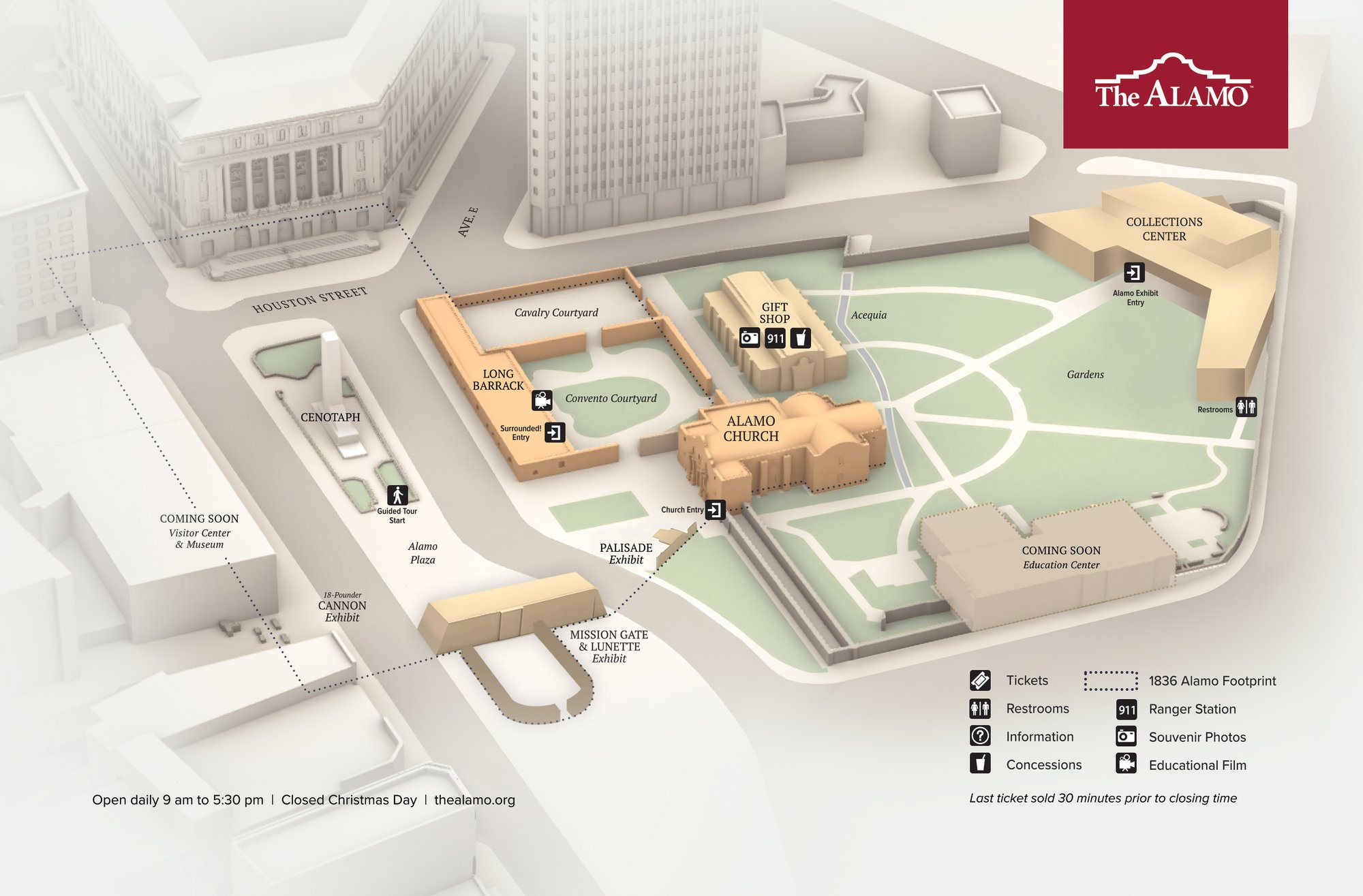
The map of the Alamo during the siege was anchored by the Long Barrack. This was a two-story building where most of the actual hand-to-hand fighting happened during the final minutes of the battle. It’s still there today, though much of it was rebuilt. To the south was the Low Barrack and the main gate, which was guarded by a small timber-and-earth fortification called a lunette.
Santa Anna’s troops didn’t just charge the front door. They hit the north wall. This was the weakest point of the entire map of the Alamo. It was basically a crumbling stone wall reinforced with timber and earth. When the Mexican soldadores breached that section, the defense collapsed inward. It became a chaotic scramble toward the Long Barrack and the Church.
The Plaza and the Palisade
Between the Church and the Low Barrack sat a gap. This is where David Crockett and his Tennessee boys were stationed. To fill the hole, the defenders built a "palisade"—basically a high fence made of sharpened logs and dirt. On a map of the Alamo, this looks like a weak link. In reality, it was one of the most heavily defended spots.
You’ve probably seen movies where the Texans are standing on high stone walls. Some were. But many were tucked into "cow pens" or behind earthworks. The interior of the plaza was a wide-open space. This was a nightmare for the defenders. Once the walls were breached, there was nowhere to hide. The map of the Alamo became a trap.
The scale is what trips people up. The compound stretched all the way to what is now the middle of Alamo Plaza, across the street to where the shops and museums sit today. When you stand in front of the Church today, you are actually standing inside what used to be the courtyard.
Why Modern Maps Are Confusing
If you look at a Google Map of San Antonio right now, the "Alamo" is a tiny speck. This is because most of the original 1836 site is buried under asphalt. For decades, the city grew right over the top of the battlefield. The Menger Hotel sits on part of it. The Hipolito F. Garcia Federal Building sits on another chunk.
Recently, the "Alamo Plan" has been trying to fix this. It’s a massive, multi-million dollar project to reclaim the footprint. They’ve been doing archaeological digs to find the original western wall. They actually found it under the sidewalk. It’s wild to think that for a century, people were just walking over the spot where the wall stood without even knowing it.
- The West Wall: This was located roughly where the shops are across from the plaza.
- The South Gate: This was near the current intersection of Alamo and Crockett streets.
- The North Wall: This stretched toward the current post office building.
The map of the Alamo is being redrawn in real-time by historians and archaeologists like those from the Texas Historical Commission. They are finding bullet casings, uniform buttons, and even bits of horseshoes that help pinpoint exactly where the lines were.
The Acequias: The Lifeblood and the Weakness
You can't understand the map of the Alamo without looking at the water. The San Antonio River is nearby, but the mission relied on acequias—man-made ditches. One ran right through the compound. This provided water, sure, but it also meant there were soft spots in the perimeter. Santa Anna knew this. He cut off the water supply early in the 13-day siege.
Imagine being trapped in a four-acre stone box in the Texas heat with no fresh water. The map tells the story of the geography, but the lack of water tells the story of the desperation.
Examining the Labastida Map
The most important historical map of the Alamo was drawn by Ignacio de Labastida. He was Santa Anna’s field engineer. He drew it before the final assault. What makes his map so valuable is the detail. He marked the location of the Mexican batteries—the cannons that pounded the walls for nearly two weeks.
- He showed the "Entrenchments" inside the church.
- He mapped the "Corrals" on the east side.
- He noted the height of the walls.
Labastida’s map shows us that the Mexican army wasn't just blindly charging. They had a technical understanding of the fort's vulnerabilities. They knew the north wall was sagging. They knew the church lacked a roof, making it vulnerable to plunging fire.
The defenders, led by Travis, had their own maps—or at least mental ones. Travis sent out several couriers with pleas for help. If you track the routes of those couriers on a map of the Alamo and the surrounding San Antonio de Béxar, you realize how surrounded they really were. The Mexican cavalry circled the entire town. There was no easy way out.
How to Visualize the Site Today
If you visit, don't just go inside the Church. That’s a mistake. Instead, stand at the "Cenotaph"—the big monument in the plaza. Look toward the shops across the street. That was the West Wall. Look north toward the post office. That was the North Wall.
Basically, the entire pedestrian plaza you are standing in was the interior of the fort.
The Long Barrack is the best place to get a sense of the 1836 map of the Alamo. It’s the oldest building on the site. Inside, the walls are thick. You can see where the rooms were divided. This wasn't an open hallway; it was a series of small, dark rooms. This is where the battle ended—in the dark, in small rooms, with knives and bayonets.
Misconceptions That Mess With the Map
A big one: The "Hump."
Again, that iconic silhouette wasn't there in 1836. If you see a map of the Alamo or a drawing that shows the curved top during the battle, it’s wrong. It was a flat-topped, jagged ruin.
Another one: The "Tunnel."
There are always rumors about secret tunnels connecting the Alamo to other missions. Archaeologists haven't found them. The "tunnels" people see are usually just the old acequias or drainage pipes from the late 1800s. The defenders weren't going underground. They were stuck.
The map of the Alamo is also a map of burial sites. We don't actually know where all the defenders were burned or buried. Most were placed in funeral pyres near the site. Some remains were reportedly moved to the San Fernando Cathedral later. The map of the battle is also a map of a cemetery, which is why the site is treated with such reverence today.
Practical Insights for Your Visit
If you want to truly understand the layout, don't rely on the signs alone.
- Download a PDF of the 1836 footprint before you go. Overlaying it on your phone's GPS while you walk the plaza is a game-changer.
- Look for the brass markers in the ground. The city has placed markers in the pavement to show where the original walls stood. Follow the line. It goes much further than you think.
- Visit the San Pedro Springs. It’s not at the Alamo, but it’s where the water came from. It helps you understand why the mission was built where it was.
- Check out the "Alamo Revealed" exhibits. They use augmented reality to show you the walls rising up from the modern streets. It’s one of the few times tech actually makes history clearer.
The map of the Alamo is a living document. Every time a utility company digs a hole in downtown San Antonio, there’s a chance they’ll find a piece of the wall or a discarded uniform button. It’s a 300-year-old puzzle that we are still putting together. Understanding the map is the only way to understand why the battle happened the way it did—a massive, crumbling mission that was simply too big for 180 men to hold against thousands.
To get the most out of the site, start your walk at the corner of Alamo and Houston streets. This was the far north-west corner of the compound. From there, walk south toward the Menger Hotel. You've just walked the length of the main plaza. By the time you reach the Church, you'll realize just how much ground those few defenders were trying to cover. It makes the "13 days" story much more impressive when you see the sheer physical scale of the task they had.